our Projects

  • 01/

    Bear park Project

    The Bear Park Project was completed in 1984. The designed to hold 4000 acre feet of water during high runoff events, reducing flood damages on the Sand Hill and Red River.
  • 02/

    V. Olson Dam

    The Verdell Olson Dam began with the construction of a detention dam in the outlet channel from a 50 acre basin. The dam eliminated damages caused by extremely high flows each spring.
  • 04/

    Winger Dam

    The proposed Winger Dam was designed to hold 12,000 acre feet creating a lake with 6,000 acrea feet of possible flood storage. After years of effort and expense, the project died due to the inability to obtain proper permiting from the US Army Corp and MN DNR.
  • 08/

    Ogaard Impoundment

    The Verdell Olson Dam began with the construction of a detention dam in the outlet channel from a 50 acre basin. The dam eliminated damages caused by extremely high flows each spring.
  • 09/

    River Clean up

    To complement the district's missions statement, the district supported all efforts to clean our local river. Tires, mattresses, garbage, carcuses, and appliances were just a few things found and removed from our river.
  • 09/A

    River Stabilization

    The Sand Hill River Watershed district installed riprap at four erosion protection areas along the Sand Hill River. Three of these areas are located in the vicinity of the city of Fertile in sections 20 and 29 of Garfield Township. The fourth site is located in the NW 1/4 of sect(ion 28, Liberty Township.
  • 10/

    West Mill

    The City of Fertile petitioned the Sand Hill River Watershed District with a proposed recreational lake west of Fertile at the site of a feed mill that failed in 1950. The project died due to a lack of funding and MN DNR permitting restraints.
  • 15/

    Ring Dikes

    Farmstead Ring Dikes
    City Ring Dikes
    The Sand Hill River Watershed District has assisted in the construction of many ring dike projects, mostly on the west end of the district. The latest project is a ring dike around the City of Climax. The district is waiting funding for a ring dike around the City of Nielsville
  • 16/

    Kurass Lake

    The Watershed District assisted Garfield Township in 1998 with control structure to lower the lake level of Kurass Lake and establish an ordinary high water level.
  • 18/

    Vesledahl Wetland Banking

    Multiple agencies planned to develop and restore areas of wetlands that will serve as a "bank" for wetland "credits" to be used to offset damages done to other wetlands for road construction projects.
  • 19/

    Union Lake Erosion Control

    The district discovers a a workable solution for solving the erosion that was occurring at the site in section 31 of Knute Township, Polk County, Minnesota.
  • 21/

    Fish Passage

    Since the early 2000's the Sand Hill River Watershed District has collaborated with partnering agencies to restore the Sand Hill River and make it a viable fishery once again.
  • 22/

    Section 23/Russia Boundary

    Collaboration between the Red Lake Watershed District and the Sand Hill River Waterhsed District solves flooding for local landwoners.
  • 23/

    Section 23/Russia Boundary

    Collaboration between the Red Lake Watershed District and the Sand Hill River Waterhsed District solves flooding for local landwoners.
  • 28/

    King Township- Hopke Diversion

    The district cost shares with King Township to maintain the district's policy to manage water through a grass waterway vs. crossing farm fields.
  • 29/

    Rock riffles

    The Sand Hill River Watershed District collaborated with many partners to minimize future head cutting along the Sand Hill channel and reduce to occurrence of bank sluffing.
  • 30/

    Jerde/Taylor Erosion control

    The District helps landowners implement erosion control measures in Section 13 of Liberty Township.


Olson Dam

Project # 2

Olson_Dam
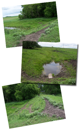
Project No. 2 is located in Section 21 of Garden Township in Polk County. The outlet to this basin filled with snow each winter and during the spring run off, the basin would fill with with water. Upon snow melt, the ditch would send a torent of water downstream, causing the towship road and culvert to blow out. The flooding would then spill over Polk County #1. This created a dangerous situation for traffic and continuous damage to the township road and culvert. The detention dam began was constructed in the outlet channel and included a 24" pipe which held water back for several days with a gradual release, eliminating damages.

On June 5, 1975, the Board authorized preliminary studies on this project. On October 2, 1979, the Engineer's Report was presented to the Board. The Board hoped to fund this project totally between the Lower Red River Water Management Board and the Sand Hill River Watershed District. On October 3, 1979, the Sand Hill Board was granted 90% funding from the Lower Red River Watershed Management Board for this project.

The Department of Natural Resources permit was applied for on October 5, 1979. The report of the Director, Division of Waters, Minnesota Department of Natural Resources, was received December 14, 1979. This conditional permit authorized the Board to construct this dam after the Dam Safety Section approved the final plans and specifications. Dam Safety Section's approval came with the authroized permit on December 28, 1979. The Water Resources Board's comments were received January 18, 1980.

The Bid opening was held July 1, 1980. The total project cost was just under $12,000.

The SHRWD is currently working at developing a solution to resolve long standing drainage issues upstream of the dam. Historically the upstream watershed was primarily drained and under agricultural production. As a part of this effort, the SHRWD plans to coordinate with regulating officials to determine an acceptable modification to the structure. The SHRWD also recently completed a sediment cleanout of the downstream channel to remove any blockages.