The Bear Park Project was completed in 1984. The designed to hold 4000 acre feet of water during high runoff events, reducing flood damages on the Sand Hill and Red River.
The Verdell Olson Dam began with the construction of a detention dam in the outlet channel from a 50 acre basin. The dam eliminated damages caused by extremely high flows each spring.
The proposed Winger Dam was designed to hold 12,000 acre feet creating a lake with 6,000 acrea feet of possible flood storage. After years of effort and expense, the project died due to the inability to obtain proper permiting from the US Army Corp and MN DNR.
To complement the district's missions statement, the district supported all efforts to clean our local river. Tires, mattresses, garbage, carcuses, and appliances were just a few things found and removed from our river.
The Sand Hill River Watershed district installed riprap at four erosion protection areas along the Sand Hill River. Three of these areas are located
in the vicinity of the city of Fertile in sections 20 and 29
of Garfield Township. The fourth site is located in the NW
1/4 of sect(ion 28, Liberty Township.
The City of Fertile petitioned the Sand Hill River Watershed District with a proposed recreational lake west of Fertile at the site of a feed mill that failed in 1950. The project died due to a lack of funding and MN DNR permitting restraints.
The Sand Hill River Watershed District has assisted in the construction of many ring dike projects, mostly on the west end of the district. The latest project is a ring dike around the City of Climax. The district is waiting funding for a ring dike around the City of Nielsville
The Watershed District assisted Garfield Township in 1998 with control structure to lower the lake level of Kurass Lake and establish an ordinary high water level.
Multiple agencies planned to develop and restore areas of wetlands that will serve as a "bank" for wetland "credits" to be used to offset damages done to other wetlands for road construction projects.
The district discovers a a workable solution for solving the erosion that was occurring at the site in section 31 of Knute Township, Polk County, Minnesota.
Since the early 2000's the Sand Hill River Watershed District has collaborated with partnering agencies to restore the Sand Hill River and make it a viable fishery once again.
The Sand Hill River Watershed District collaborated with many partners to minimize future head cutting along the Sand Hill channel and reduce to occurrence of bank sluffing.
The District helps landowners implement erosion control measures in Section 13 of Liberty Township.
Fish Passage
Project # 21
In 2003, the Sand Hill River Watershed began preliminary investigations to address alternatives that could make the
Sand Hill River a viable fishery. The project team's analysis showed four impediments to fish passage on the Sand Hill River and include:
The four drop structures on the USACE Project
Downstream of the last drop structure to a point
west of the county bridge, a distance of 500 to 1000
feet
The Texas crossing west of Highway No. 9
The box culverts west of Fertile
A DNR fisheries grant was awarded to the district to begin the project. It was decided to begin with the Texas Crossing (West of Beltrami) and the West Mill site (West of Fertile). In September of 2006, the project was awarded to Davidson Construction and Ready Mix of Newefolden, MN. The two sites were completed and ready for seeding in the spring of 2007
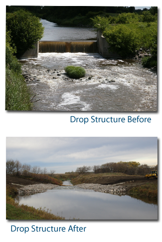
Following completion of the Texas Crossing and West Mill projects, the US Army Corps of Engineers (USACE) began a Section 1135 project to restore fish passage over the four drop structures. The Section 1135 project would provide 75% federal funding, leaving 25% required from non-federal partners. The design was developed in close consultation with the MN DNR, and in 2015 MN provided the local funds through the Lessard-Sams Outdoor Heritage Council. The USACE moved forward with the federally led project, and completed retrofit of the four drop structures with riprap to provide fish passage in 2017.
Phase 2 - Kittleson and SH Lake Dam
Construction for the original fish passage restoration portion of this grant was completed and costs were well below estimates. The district continues to move forward and fish passage will be restored at two additional sites in the Sand Hill River watershed with the unspent funds. The first barrier is the roadcrossing on Kittleson Creek, a tributary to the Sand Hill River (West of Fertile, MN). This culvert is nearly perched and velocities exceed the swimming limits for most species at normal flows. This restoration would replace the culvert with a structure more appropriately sized for the creek and at a lower elevation to accommodate fish passage. The second barrier is a dam on Sand Hill Lake. The dam will be removed and replaced with rock arch rapids to allow fish passage upstream into Sand Hill Lake. Both of these crossings are upstream of the dams that were modified for fish passage in 2017. Restoration of fish passage at these two sites would expand the number of restored acres and river miles in the watershed. Numerous fish passage restoration projects have been conducted in the Red River basin, with almost immediate positive impacts to fishcommunities. A fish passage project similar to the one proposed for the Sand Hill River was conducted on the Wild Rice River, another major tributary to the Red River. Fisheries surveys found a low head dam on the Wild Rice River blocked fish passage and impacted populations. Similar to findings on the Sand Hill River, large river fish species such as Channel Catfish, Freshwater Drum, Goldeye,Sauger, Smallmouth Bass, and Walleye were common below but rarely captured above the dam. Within one year of passage restorationat this dam in the Wild Rice, these large river species were common upstream of the dam, with channel catfish captured 70 river miles above the previous barrier. Restoration of fish passage on the Sand Hill River would likely yield similar results. A second component of this project will enhance stream habitat within a channelized segment of the Sand Hill River downstream of the four drop structures (West of Fertile, MN). The river channel in this reach is unstable and has down cut significantly, creating a simplified habitat lackingin diverse substrate and depth. Habitat will be enhanced by constructing rock riffles in the channel to reduce velocities, increase pool/riffle habitat and provide more diverse substrate. The enhanced habitat would likely be used by many fish species for spawning, juvenile, and year round deep cover.
Construction for the Sand Hill Lake Dam was completed in March of 2020. The construction plans can be found here.
Poissant Bridge
In 2021, the district removed a bridge and concrete wing walls and abutments over the Sand Hill River and replaced it with a rock riffle for grade control and fish passage. This involved minor excavation and filling to create the rock riffle. The 175 linear foot rock riffle began at elevation 1074.14 at the top end and extend downstream with a 3% slope to elevation 1072.37. The rock riffle is U-shaped with the center of the channel flow in the center of the rock riffle. Slopes of the rock riffle are set to a 3% slope or flatter. The riffle is keyed into the banks a minimum of ten (10) feet horizontally and all disturbed were reseeded. During construction, a bank failure on the south side of the channel just downstream of the rock arch rapid was noted. Additional riprap was brought in to extend the ramp approximately 40ft downstream to protect the bank in this location from further erosion.