The Bear Park Project was completed in 1984. The designed to hold 4000 acre feet of water during high runoff events, reducing flood damages on the Sand Hill and Red River.
The Verdell Olson Dam began with the construction of a detention dam in the outlet channel from a 50 acre basin. The dam eliminated damages caused by extremely high flows each spring.
The proposed Winger Dam was designed to hold 12,000 acre feet creating a lake with 6,000 acrea feet of possible flood storage. After years of effort and expense, the project died due to the inability to obtain proper permiting from the US Army Corp and MN DNR.
To complement the district's missions statement, the district supported all efforts to clean our local river. Tires, mattresses, garbage, carcuses, and appliances were just a few things found and removed from our river.
The Sand Hill River Watershed district installed riprap at four erosion protection areas along the Sand Hill River. Three of these areas are located
in the vicinity of the city of Fertile in sections 20 and 29
of Garfield Township. The fourth site is located in the NW
1/4 of sect(ion 28, Liberty Township.
The City of Fertile petitioned the Sand Hill River Watershed District with a proposed recreational lake west of Fertile at the site of a feed mill that failed in 1950. The project died due to a lack of funding and MN DNR permitting restraints.
The Sand Hill River Watershed District has assisted in the construction of many ring dike projects, mostly on the west end of the district. The latest project is a ring dike around the City of Climax. The district is waiting funding for a ring dike around the City of Nielsville
The Watershed District assisted Garfield Township in 1998 with control structure to lower the lake level of Kurass Lake and establish an ordinary high water level.
Multiple agencies planned to develop and restore areas of wetlands that will serve as a "bank" for wetland "credits" to be used to offset damages done to other wetlands for road construction projects.
The district discovers a a workable solution for solving the erosion that was occurring at the site in section 31 of Knute Township, Polk County, Minnesota.
Since the early 2000's the Sand Hill River Watershed District has collaborated with partnering agencies to restore the Sand Hill River and make it a viable fishery once again.
The Sand Hill River Watershed District collaborated with many partners to minimize future head cutting along the Sand Hill channel and reduce to occurrence of bank sluffing.
The District helps landowners implement erosion control measures in Section 13 of Liberty Township.
Bear Park
Project # 1
Project Overview
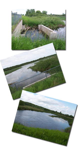
The Bear Park Project is a flood detention structure located on the Sand Hill River in Bear Park Township, Norman County, Minnesota. Originally constructed to replace an aging bridge crossing, the project was designed to provide both a safe roadway crossing and flood damage reduction benefits for the watershed.
Completed in 1982, the structure provides approximately 3,800 acre-feet of temporary floodwater storage and has helped reduce flood damages along the Sand Hill River and throughout the Red River Basin. The impoundment area extends approximately 4.5 miles upstream to the Polk and Mahnomen County line.
Purpose and benefits
The Bear Park Project was developed to help address flooding within the Sand Hill River Watershed by temporarily storing runoff during periods of high flow. By reducing peak flows, the project provides benefits to downstream landowners, communities, infrastructure, and agricultural lands.
Project benefits include:
Reduction of peak flood flows during major runoff events
Protection of agricultural lands and infrastructure
Support of regional flood damage reduction efforts
Temporary floodwater storage without a permanent pool
Long-term watershed management benefits
Project funding
The Bear Park Project was made possible through a partnership between local and state government entities committed to reducing flood damages within the Sand Hill River Watershed. On October 2, 1979, the Lower Red River Water Management Board and the Minnesota Department of Natural Resources entered into a funding agreement providing assistance through the Legislative Commission on Minnesota Resources (LCMR).
Under the agreement, the State of Minnesota committed to funding 50 percent of eligible project costs, not to exceed $180,500. This investment helped make construction of the project possible while reducing the financial burden on local taxpayers.
The partnership reflected a shared recognition that flood damage reduction projects provide benefits extending beyond local boundaries. More than four decades later, the Bear Park Project continues to provide flood storage and downstream flood protection benefits, demonstrating the long-term value of investments in watershed infrastructure.
Project Timeline
Date
Milestone
1977
The Board of Managers authorized preliminary investigations to evaluate replacing the existing bridge crossing with a structure capable of providing floodwater storage benefits.
September 13, 1978
The Bear Park Project was officially established by the Sand Hill River Watershed District.
March 15, 1979
The preliminary engineering report was completed and submitted to the Board of Managers.
March 19, 1979
Copies of the preliminary engineering report were submitted to the Minnesota Water Resources Board and Minnesota Department of Natural Resources for review.
March 20, 1979
Permit application submitted to the Minnesota Department of Natural Resources.
March 23, 1979
Permit application submitted to the U.S. Army Corps of Engineers.
July 10, 1979
Public hearing held on the Engineer's Report and Viewer's Report.
July 17, 1979
The Board of Managers directed legal counsel to proceed with condemnation proceedings for lands not acquired through easement agreements.
July 26, 1979
Comments from the Minnesota Water Resources Board were received.
October 2, 1979
Funding agreement executed between the Lower Red River Water Management Board and the Minnesota Department of Natural Resources. Through the Legislative Commission on Minnesota Resources (LCMR), the State agreed to fund 50 percent of project costs, not to exceed $180,500.
January 22, 1980
Validated permit received from the U.S. Army Corps of Engineers.
May 27, 1980
Petition for condemnation filed to acquire remaining lands needed for project construction.
July 2, 1980
Preliminary condemnation hearing held in Mahnomen, Minnesota. The required lands were subsequently made available to the Board later in 1980.
October 21, 1980
Additional information requested by the Minnesota DNR Dam Safety Section was submitted.
October 29, 1980
Bid opening conducted. Drewes Construction Company of Detroit Lakes submitted the low base bid of $183,132.55.
November 18, 1980
Additional information requested by the Minnesota DNR Dam Safety Section was submitted.
November 26, 1980
Minnesota Department of Natural Resources permit received.
December 15, 1980
Construction contract awarded to Drewes Construction Company of Detroit Lakes, Minnesota.
June 10, 1981
Construction of the Bear Park Project began.
October 1981
Major construction activities were substantially completed, with only seeding and minor cleanup remaining.
July 1982
Project completed and officially accepted by the Board of Managers. Final construction cost was $202,905.85.
1984
Drewes Construction completed an access road within the reservoir area.
2013
The District initiated an alternatives analysis to identify opportunities for additional floodwater storage and flood damage reduction. Potential improvements included up to 5,600 acre-feet of gated storage, enhanced benefits for lands adjacent to the Sand Hill River and Red River, and support of the Red River Basin Commission's Flood Damage Reduction Strategy.
2026
The Board of Managers established the Bear Park Project Team to explore opportunities for additional flood damage reduction, water quality improvements, and other watershed benefits associated with the Bear Park area.
```
Project Maintenance
The Sand Hill River Watershed District conducts regular inspections and maintenance activities to ensure the project continues to function as intended.
Maintenance efforts have included:
Structure inspections and maintenance
Beaver dam and lodge monitoring and removal
Drone and field surveys
River corridor inspections
River cleanup activities
These efforts help protect the public investment in flood damage reduction infrastructure and maintain the project's long-term effectiveness.
Looking ahead
The Bear Park Project continues to play an important role in reducing flood damages within the watershed. As watershed needs evolve, the Sand Hill River Watershed District continues to evaluate opportunities that could build upon the success of existing infrastructure.
In 2026, the Board of Managers established a Bear Park Project Team to explore opportunities for additional flood damage reduction, water quality improvements, and other watershed benefits associated with the Bear Park area. The team provides a forum for stakeholder input and helps identify concepts that may warrant future evaluation.
The formation of the Project Team does not commit the District to any specific project. Rather, it allows local stakeholders, landowners, and agency representatives to collaboratively discuss ideas, evaluate potential benefits and impacts, and determine whether additional study is appropriate.
 Project Overview
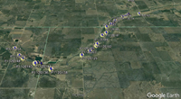 The Sand Hill River Watershed District conducts regular inspections and maintenance activities to ensure the project continues to function as intended.